Excerpts from
Teaching with Documents: Using Primary Sources from the National Archives
National Archives and Records Administration and National Council for the
Social Studies
Washington, D.C.
1989
Since the 18th century, the Federal Government has encouraged and promoted the orderly distribution and development of publicly owned land in the United States. This has been done, in part, by the passage of legislation providing for its sale to private citizens at public auction.
The earliest ordinance dealing with land sales was that of 1785, and it was designed by the Continental Congress to establish a system for the distribution of land west of the original Thirteen Colonies. This ordinance ordered a land survey and provided for the establishment of townships 36 miles square. The smallest parcel of land, comprising 640 acres, was called a "section" and could be purchased for a minimum price of $1.00 an acre. There was no limit to the amount of land that a purchaser could buy, and speculation was both legal and common. District land offices were created by the Treasury Department to supervise the auctions at which much of this land was sold. Two years later, in 1787, the Northwest Ordinance established procedures by which the newly settled lands would become States.
Sale of public land has continued through the 19th and into the 20th centuries. The Homestead Act of 1862 encouraged farmers to settle by offering them 160 acres of land at no cost to heads of families who agreed to live on the land for at least five years. Land was also offered as a recompense for military service during the 19th century, and today it is still possible to buy remotely situated parcels of land in such areas as Alaska and the Far West.
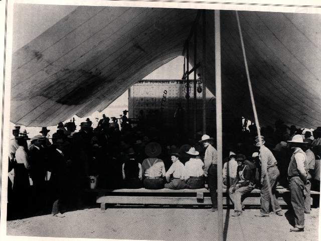
Reproduced here is a photograph of a land auction—whether public or private is not known—in Imperial, California, in 1904. Until the 20th century, the southernmost area of California was an unpopulated, arid wasteland known as the Colorado Desert. By 1905, land developers had built a canal to connect the area with the Colorado River, which would provide necessary water. Towns were established and lots were sold. Despite occasional flooding from the Colorado River, the area prospered. Construction of the Boulder (later Hoover) Dam in Nevada in 1936 controlled the flooding in the valley and secured the future of the area. Today the Colorado Desert is called the Imperial Valley and is one of the richest agricultural areas of California.
Photographs are valuable sources for studying history. However, like written documents, they reflect the point of view or bias of the photographer and must be used with care. It is useful, for example, to know who took a photograph and for what purpose. The original of this photograph, with many others of the valley, was sent to E.A. Hitchcock, Secretary of the Interior, by A.H. Heber, president of the California Development Company. Heber was one of the developers of the Imperial Valley.

This is photograph 48-RST-7-25 in Records of the Office of the Secretary of the Interior, Record Group 48.
Suggestions for Teaching
1. You can reproduce this photograph for your students on a photocopying machine. Use it as the basis for a discussion on using photographs as historical evidence. We suggest you consider these questions in your discussion:
a. What is happening in the photograph?
b. What details in the photograph provide clues about what is happening?
c. What details in the photograph reveal the date of the event?
d. Is there evidence in the photograph to place it in a particular location?
e. If you knew that this photograph recorded a public auction, what conclusions could you draw from it?
f. Would these conclusions change if the photograph recorded an auction held by the land developer?
2. Use this photograph with others from your textbook or from other sources to discuss with students how to use photographs as evidence. Ask students to review each photograph for details. For example, they should notice such elements as means of transportation, geography, lighting fixtures, furnishings, architectural styles, and clothing. Students should also consider the possible point of view of the photographer and how his or her purpose could affect the photograph.
3. Use a map of your town as the basis for a mock land sale. Before your sale, discuss with students:
a. How would you conduct a sale fairly? Establish the rules for a public auction.
b. Would you allow real estate developers to compete with individual buyers?
c. What is a zoning ordinance? How would you determine residential and commercial zones? Where would you build parks and schools?
d. Would buyers be extended credit or be required to pay cash?
e. How would you, as a city official, use the money from the land sale?
f. Who would pay for public services, such as street lights and garbage collection?
4. Invite someone from the city development office to come and talk with your class about city policies toward land sales.
5. Develop a time line of events and legislation concerning the settlement of the West.
a. When was the last land rush?
b. When was the reservation system established for American Indians?
c. When were the national parks established?
d. When did the California gold rush begin?
e. Ask students to find photographs to illustrate some of these events.
6. Use this photograph as the basis for a small-group project. Direct students to investigate the survey system of the Ordinance of 1785. Ask them to report to the class on the township-range survey system established by the ordinance. Aerial photographs provide modern evidence of the widespread influence of this survey system.