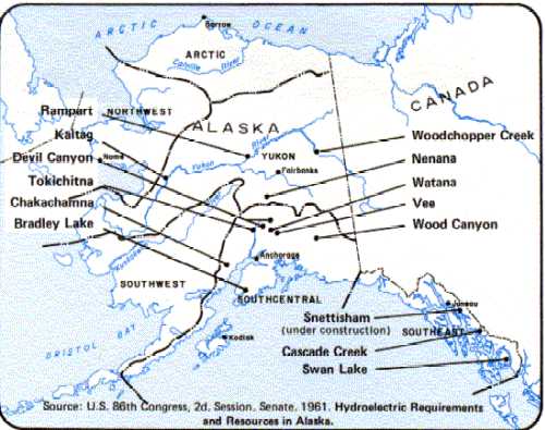
Figure 145
Proposed Major Hydroelectric Power Sites in Alaska
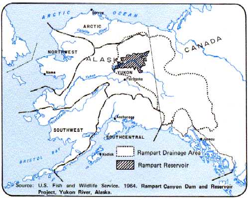
Figure 146
Proposed Rampart Canyon Dam Reservoir and Drainage
Basin
Geothermal
Active geologic and tectonic processes have led to the occurrence of numerous geothermal systems in the Yukon Region (Figure 120). These systems may be a source of energy in areas where high heat flow and thermal gradient values are accompanied by water occurrence in the fractures and pore spaces in the host rock. Growing concerns about energy have sparked new interest in geothermal sources. Figure 121, the result of recent studies done throughout Alaska (Forbes and Biggar 1973), shows areas of prospective geothermal resources as well as Alaska's thermal springs and their relative temperatures.
Figure 122 presents 20 of the major hot springs in the westcentral part of Alaska as described by Miller, Barnes, and Patton (1973). All of the hot springs are associated with the contacts of intrusive bodies, but their distribution does not depend on the age and composition of the pluton or on the age and type of the surrounding country rock. The geologic and chemical data, although preliminary, suggest that most of the hot springs of westcentral Alaska have relatively low subsurface temperatures and limited reservoir capacities compared to geothermal areas presently being utilized for electrical power generation in other parts of the world. Current and historical use of hot springs throughout central Alaska have been for recreational, bathing, and limited agricultural purposes. Areas considered favorable for geothermal resources are outlined on Figures 116 and 118.
Figure 122
Description and Geologic Setting of Major Hot Springs in West-central Alaska
|
Name |
Location |
General Description |
|
Hawk River |
66º14'N., 157º35'W.; Shungak 1:250,000 quadrangle; 80 km (50 mi) south-southwest of Kobuk |
At least one hot spring is in east bank of Hawk River on south side of Purcell Mountains. Spring is at south end of clearing 25 m by 60 m (75 ft by 200 ft) in tall timber and flows directly into Hawk River. Temperature estimated at +50ºC. No chemical analysis available. Spring lies about 400 m (0.25 mi) south of Hawk River pluton and very close to east-west fault that cuts pluton (Miller 1970) |
|
South |
66º09'N., 157º07'W.; Shungak 1:250,000 quadrangle; 84 km (52 mi) south of Kobuk on south side of Purcell Mountains |
Several hot springs scattered about a west-facing timbered slope 60 to 120 m (200-400 ft) above south-flowing tributary to Hawk River. Only one hot spring visited. Temperatures estimates at +50ºC. Chemical analysis available. Springs are in Late Cretaceous-aged Wheeler Creek pluton (miller 1970) and are approximately on conspicuous lineament trending N. 80ºW. (Patton et al. 1968). |
|
Purcell Mountain |
66º23'N., 157º32'W.; Shungak 1:250,000 quadrangle; 71 km (44 mi) south-southwest of Kobuk |
Spring is on north bank of unnamed nort-flowing tributary to Shinilikrok Creek about 8 km (5 mi) northeast of Purcell Mountain. Small flow, temperature estimated at 15º-20ºC. No chemical analysis available. Spring is in Late Crettaceous volcanic complex (Patton et al. 1968) and near contact with granitic pluton (Miller 1970). |
|
Division |
66º22'N., 156º44'W.; Shungak 1:250,000 quadrangle; 61 km (38 mi) south of Kobuk on north side of Purcell Mountains |
Numerous springs on both sides of a headwater stream of Selawik River. Large open meadows as much as 900 m (1,000 yd) long by 180 m (200 yd) wide; largest area of apparent thawed ground of any hot spring in western Alaska. Temperature estimated at 50º-60ºC. No chemical analysis available. Springs are in Lower Cretaceous volcanic rocks near conspicuous N.70º W.-trending lineament and about 2.5 km (1.5 mi) north of Wheeler Creek pluton (Patton et al. 1968; Miller 1970). |
|
Deniktow Ridge |
65º54'N., 155º00'W.; Melozitna D-4 quadrangle |
Melozitna D-4 topographic map (1:63,000 scale) shows hot-spring symbol on north side of Hot Springs Creek 8 km (5 mi) from Koyukuk River. Not visited by us and no information regarding temperature, flow, number of springs, or chemistry is available. Spring locality is in area of numerous dikes and widespread thermal metamorphism, suggesting an unexposed pluton at shallow depth (Miller and Ferrians 1968). |
|
Tunalkten Lake |
66º11'N., 154º01'W.; Hughes A-3 quadrangle; 19 km (12 mi) northeast of Hughes 2.4 km (1.5 mi) from Koyukuk River |
Hot-spring symbol shown on Hughes 1:250,000-scale quadrangle. Spring locality about 4 km (2.5 mi) west of Indian Mountain pluton (Patton and Miller 1966). |
|
Reported hot spring |
General location: east side of Kaiyuh Hills |
Waring (1917) quotes prospector as reporting a hot spring on tributary of upper Innoko River. No other information available. |
|
Horner |
64º55'N., 154º47'W.; Ruby D-4 quadrangle; 40 km (25 mi) northeast of Ruby on north side of Yukon River |
Hot springs issue from several points along small spring on west side of creek (Waring 1917). Temperatures range from 30º-49ºC. Chemical analysis available. According to Waring (1917), springs are in fractured granite of small pluton. Springs are near Kaltag fault (Patton and Hoare 1968). |
|
Dulbi |
65º16'N., 155º16'W.; Melozitna B-5 quadrangle; 31 km (19.5 mi) N. 61ºW. of Melozi Springs |
Several hot springs are found within a distance of about 100 m (100 yd) in small clearing along west side of south-flowing tributary to Dulbi River. Temperatures estimated at 50º-60ºC. No chemical analysis available. Spring is in sedimentary rocks of Cretaceous age about 3.2 km (2 mi) from a possible pluton inferred from aerial photographs. |
|
Melozi Hot Springs (Melozitna) |
65º08'N., 154º40'W.; Melozitna B-1 quadrangle; on Hot Springs Creek 48 km (30 mi) northeast of Ruby |
From Waring (1917): One main hot spring flowing over 5 m (17 ft) bank into Hot Springs Creek. Temperature measured at 55ºC. Total flow of 8.3 1/s (130 gal/min). H2S odor. Chemical analysis available. Spring is in pluton. |
|
Little Melozitna Hot Springs |
65º28'N., 153º20'W.; Melozitna B-1 quadrangle; 64 km (40 mi) west of Tanana |
Hot springs on west bank of Hot Springs Creek. Temperature of 38ºC (Waring 1917). H2S odor. Partial chemical analysis available. From Waring (1917); Springs are in small granitic pluton. |
|
Manley Hot Springs (Baker Hot Springs) |
65º00'N., 150º38'W.; Tanana A-2 quadrangle; at north edge of Manley Hot Springs |
Principal hot springs are in valley of Karshner Creek, a tributary to Hot Springs Slough. Temperature of 50ºC measured. In 1915 area had 0.25 km2 (60 acres) under cultivation (Waring 1917). Chemical analysis available. Presence of abundant large blocks of biotite granite float suggests pluton contact is close. |
|
Hutlinana |
65º13'N., 149º59'W.; Livengood A-6 quadrangle; 110 km (70 mi) west of Fairbanks |
Several hot springs are found within a distance of about 10 m (30 ft) on west side of Hutlinana Creek. Faint H2S odor. Temperature of 43ºC; discharge estimated at about 3 1/s (50 gal/min) (Waring 1917). Chemical analysis available. Spring is about 5 km (3 mi) east of granitic pluton of Cretaceous and (or) Tertiary age. |
|
Tolovana |
65º16'N., 148º50'W.; Livengood B-4 quadrangle |
From R.M. Chapman, written commun., 1972: Several hot springs are found along west side of creek draining east side of Hot Springs Dome. Temperatures of 60ºC measured. Chemical analysis available. Springs are in mudstone of Jurassic and(or) Cretaceous age about 1.5 km from granitic rocks of Cretaceous and(or) Tertiary age exposed in the Tolovana Hot Springs Dome. |
|
Reported hot spring near Little Minook Creek |
General Location: 66º25'N., 150º00'W.; Livengood B-6 or Tanana B-1quadrangles |
Waring (1917) gives prospectors report of a hot spring near divide between Little Minook Creek and a tributary of Hess (Hoosier?) Creek. No other information available. General area is underlain by Paleozoic conglomerate and shale and Jurassic and(or) Cretaceous mudstone cut by small intrusives of Cretaceous and(or) Tertiary age (Waring (1917; Chapman et al. 1971 ). |
|
Kilo Hot Springs |
65º49'N., 151º12'W.; Tanana D-3 quadrangle; 177 km (110 mi) northwest of Fairbanks on Kanuti Kilolitna River |
From R.M. Chapman, written commun., 1973: Several hot springs are in an open grassy area of about 100 m2 (1,000 ft2). Temperature estimated at 50ºC. No chemical analysis available. Springs issue from pluton of tentative Cretaceous age on, or very close to, contact with Precambrian (?) and Paleozoic aged rocks. |
|
Ray Hot Springs |
65º58'N., 150º55'W.; Tanana D-2 quadrangle; about 170 km (105 mi) northwest of Fairbanks on north side of Ray River |
Hot spring is at base of hill in flood plain on north side of Ray River. Slight H2S odor. Temperature measured at 47ºC. Chemical analysis available. Spring probably occurs on contact between Early Cretaceous pluton (Patton and Miller 1973) and rocks of Precambrian(?) and Paleozoic age. (Chapman and Yeend 1972). |
|
Lower Ray River |
65º59'N., 150º35'W.; Tanana D-2 quadrangle |
Several hot springs are found within a distance of 60 m (200 ft) in gravel bar on north side of Ray River. H2S odor. Temperature measured at 61ºC. Chemical analysis available. Springs are approximately on contact between pluton of probable Cretaceous age and rocks of Precambrian (?) and Paleozoic age (Chapman and Yeend 1972). |
|
Kanuti |
66º20'N., 150º48'W.; Bettles 1:250,000 quadrangle; 8 km (5 mi) southwest of Caribou Mountain |
Several hot springs are on east side of Kanuti River in large open grassy area 100 m (100 yd) in diameter underlain by alluvium. Strong H2S odor. Temperature measured at 66ºC. Chemical analysis available. Springs are in area underlain by volcanic rocks of Permian, Triassic, and Jurassic age within 400 m (0.25 mi) of contact with Cretaceous-aged Hot Springs pluton (Patton and Miller 1973). |
|
Dall Creek |
General location near Dall River in southwest Beaver 1:250,000 quadrangle |
Brosge, Brabb, and King (1970) show a possible hot spring near Dall River. General area is underlain by rocks of Precambrian or Paleozoic age intruded by granitic pluton of probably Cretaceous age. |
|
Adapted from T.P Miller. I. Barnes, and W.W. Patton, Jr., 1975. Geologic Setting and Chemical Characteristics of Hot Springs in West-Central Alaska. U.S. Geological Survey. |
||
The Geophysical Institute (Forbes et al. 1975) has recently completed a study on the feasibility of using geothermal energy resources in rural Alaskan communities. Three sites were recommended for proposed demonstrations and experiments to test a new energy extraction conceptManley Hot Springs, 90 miles (144 km) northwest of Fairbanks; Pilgrim Springs, 40 miles (64 km) north of Nome; and Clear Creek Springs, 15 miles (24 km) north of Elim.
Hydroelectric Power
The large drainage basin of the Yukon River may have the greatest electric-generating potential in North America. It is the fifth largest river basin in the United States, draining nearly 40 percent of Alaska plus most of the Yukon Territory and part of British Columbia. Six potential sites for major dams have been identified in the Yukon Regionone in Canada that would divert the headwaters to powerhouses on the coast in southeast Alaska; the Woodchopper, Rampart, and Ruby sites above the Koyukuk River and the Kaltag site below; and the Holy Cross site on the lower Yukon (U.S. Department of the Interior, Alaska Planning Group 1974). Other sites have been identified on the Koyukuk, Melozitna, Tanana, Porcupine, and Fortymile Rivers (Figures 127, 131, and 144).
| Figure 144. Inventory of Hydroelectric Power SitesYukon Region | ||||||
|
No.* |
Project Name |
Stream |
Drainage Area (sq.mi.) |
Max. Reg. Water Surface Elev. (ft.) |
Active Storage (1,000 A/F) |
Percent Stream Regulation |
|
6. |
Holy Cross |
Yukon River |
320,000 |
137 |
** |
|
|
7. |
Dulbi |
Koyukuk River |
25,700 |
225 |
22,200 |
100 |
|
8. |
Hughes |
Koyukuk River |
18,700 |
320 |
** |
|
|
9. |
Kanuti |
Koyukuk River |
18,000 |
500 |
13,800 |
100 |
|
10. |
Melozitna |
Melozitna River |
2,659 |
550 |
1,800 |
91 |
|
11. |
Ruby |
Yukon River |
256,000 |
210 |
** |
|
|
12. |
Junction Island |
Tanana River |
42,500 |
400 |
29,000 |
100 |
|
13. |
Bruskasna |
Nenana River |
650 |
2,330 |
840 |
|
|
14. |
Carlo |
Nenana River |
1,190 |
1,900 |
53 |
83 |
|
15. |
Healy (Slagle) |
Nenana River |
1,900 |
1,700 |
310 |
|
|
16. |
Big Delta |
Tanana River |
15,300 |
1,100 |
6,450 |
98 |
|
17. |
Gerstle |
Tanana River |
10,700 |
1,290 |
** |
|
|
18. |
Johnson |
Tanana River |
10,450 |
1,470 |
5,300 |
97 |
|
19. |
Cathedral Bluffs |
Tanana River |
8,550 |
1,650 |
4,900 |
100 |
|
20. |
Rampart |
Yukon River |
200,000 |
665 |
142,000 |
100 |
|
21. |
Porcupine (Campbell River) |
Porcupine River |
23,400 |
975 |
9,000 |
100 |
|
22. |
Woodchopper |
Yukon River |
122,000 |
1,020 |
39,000 |
100*** |
|
23. |
Fortymile |
Fortymile River |
6,060 |
1,550 |
1,610 |
84 |
|
24. |
Yukon-Taiya |
Yukon River |
25,700 |
2,200 |
21,000 |
100 |
|
*Numbers used in the statewide inventory. |
||||||
|
**Reservoir held essentially full for operation with upstream plants. |
||||||
|
***Operated in conjunction with downstream storage. |
||||||
|
Source: U.S. Alaska Power Administration, 1974. Alaska Power Survey. v.3. |
||||||
Of all the proposed major hydroelectric sites in Alaska (Figure 145), the Rampart project has been the most extensively studied. Projected to impound the Yukon River upstream from Rampart Canyon into a 10,850-square-mile (27,667 km2) lake (Figure 146), the Rampart damsite could have an installed capacity of nearly five million kilowatts of power. Although this project was determined to be uneconomical in 1971 (U.S. Army Corps of Engineers 1971), as nonrenewable supplies of energy become increasingly scarce the Rampart Dam again may become a feasible source of electrical energy.
|
Figure 145 |
Figure 146 |
|
|
Presently, villages and cities of the Yukon Region obtain electrical energy from small diesel generators or coal-fired steam plants. The Fairbanks area is served with steam-generated power by the Fairbanks Municipal Utilities System and the Golden Valley Electric Association. To meet future electrical power needs in the Fairbanks vicinity, potential hydroelectric sites on the Nenana River have been investigated (Figure 144).