Since the beginning of known and inferred history, the population movements in Alaska have tended to come together in the areas around Kodiak Island, Cook Inlet, and Prince William Sound contained in the Southcentral Region. We do not know how long man has lived in most of the area; however, a 6,000-year history of habitation on Kodiak and Afognak Islands has been inferred from the more than 300 known archaeological sites there (Figure 156 ).
|
| Figure 156. Chronological Chart Showing Prehistoric Cultural Phases for the Southcentral Region |
Little is known about the relationship of the Chugachimiut Eskimo culture to the Eskimo cultures of the Bering Sea and the Arctic. There is a good record of Chugach prehistory in Prince William Sound with the Palugvik site on Hawkins Island as a principal archaeological site for this region. The Yukon Island site in Kachemak Bay shows that this area of lower Cook Inlet was occupied by Eskimos from about 1500 B.C. to 1000 A.D. and then by Athabaskan Indians, probably the ancestors of the Tanaina who moved into the coastal area from the Interior.
The Eskimos of Kodiak Island subsisted primarily on salmon and marine mammals. They also hunted caribou on the Alaska Peninsula, but this was not a major item of their diet. All products of the sea, such as molluscs, cephalopods, and sea urchins were used when available (Hrdlicka 1944). The Chugachimiut of Prince William Sound represented the extreme southeastern extension of Eskimo culture. Archaeological studies indicate that the Chugachimiuts existed in Prince William Sound with little cultural change for at least 500 years prior to European contact.
It is believed that most of the Tanaina Indian groups entered the Cook Inlet subregion through the Alaska Range from the west, primarily through Rainy, Merrill, and Lake Clark Passes, and continued this southeastward extension until most of their villages were located on or near the major salmon-producing streams of Cook Inlet. The Tanaina adapted rapidly to their coastal environment, and they alone among the Athapascan-speaking peoples of Alaska hunted sea mammals. They relied primarily upon the salmon for food and utilized this and other land mammals to a lesser extent in fulfilling their dietary needs.
|
The Eyaks of the Copper River delta are historically one of the most interesting groups of Alaska Natives because they represent the point at which three major cultural ties came together. The Eyaks possessed linguistic similarities to the Copper River Ahtna people and may have migrated to the delta from interior Alaska. At the time of European contact, Eyak people were utilizing much of the central cultural structure of the Tlingits as well as some gained from Chugachimiut groups immediately to their west. This group was always quite small, its population kept in check by the raids of both Tlingits to the east and the Chugachimiut to the west (DeLaguna 1956). The approximate distribution of Alaskan Native groups in the Southcentral Region at the time of historical contact and the Euro-American settlements are shown in Figure 157 .
The great wave of European exploration first touched Southcentral Alaska with the discovery trip of Vitus Bering, who landed on Kayak Island. This Russian discovery and others were rapidly followed by Spanish explorations in Prince William Sound and by the arrival of British explorer James Cook. The difference, of course, between the Russians and the other Europeans was that the Russians came to conquer and colonize.
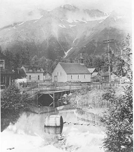
In the spring of 1784 the first Russian colony was founded on Kodiak Island at Three Saints Bay. The first Russian hunting parties were dispatched into Prince William Sound and Cook Inlet the following year. In 1792 the settlement at Three Saints Bay was moved to the present location of the city of Kodiak. By this time permanent Russian settlements had been established on the Kenai Peninsula, from which an active trading operation was carried into Prince William Sound. By 1778 Captain Cook had explored the coast of Southcentral Alaska, including the inlet which bears his name. In 1779 a Spanish expedition under Ortega and Quadra entered Prince William Sound, representing the third nation to lay claim to Prince William Sound in two years. It had been claimed previously by Cook in 1777 and in 1778, and by the Russian, Zaikof, in 1779. The only remnants of the English and Spanish exploration in Southcentral Alaska are the many place names given by Captain Cook and the Spanish explorers.
During the 83 years when the Russian American Company and the Russian government ruled together in Southcentral Alaska, the coastlines were thoroughly explored and stable settlements established on Kodiak Island and along the west coast of the Kenai Peninsula. During this period of almost a century, however, only one exploring trip was made through the Copper River canyon into the Copper River basin and one up the Susitna River.
During the first 15 years of the American period in Alaska beginning in 1867, few changes occurred. The first fish cannery was established in the Region in 1882 at Karluk, initiating the commercial fishing industry which still centers at Kodiak, in Cook Inlet, and in Prince William Sound. During the next 20 years canneries were established throughout the Region.
In 1885 Lieutenant Henry Allen explored the Copper River region. This was the first of a series of army explorations conducted in the Alaska Range. These explorations led to the next major phase of development in Southcentral Alaska—mineral discovery followed by railroad building.
|
The goldrush, which began in 1897 on the Klondike River in the Yukon Territory, largely by-passed central Alaska. However, when gold was discovered in the Fairbanks region early in the twentieth century, railroads from Prince William Sound and Cook Inlet to the Interior were emphasized. Entrepreneurs soon began to haul freight from Valdez to Fairbanks via the Richardson Trail by every possible means.
Immigration from Europe and the United States to the Region increased rapidly in the first decade of the century. In 1908 the construction of a railroad between Cordova and Chitina established Cordova as one of Alaska's leading ports, while Valdez maintained its importance as the port of entry to the newly improved Richardson Trail.
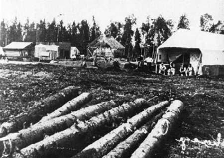
The construction of the Alaska Railroad brought large numbers of construction workers into the Cook Inlet region. Anchorage was founded as a railroad construction camp. By the time the railroad was completed in 1920, many more settlers had arrived from Europe and the United States. However, many of these newly arrived residents left Alaska in 1917 to fight in World War I and did not return.
Native populations during the American period in Southcentral Alaska generally remained stable. Disease and a high degree of infant mortality nullified the effects of a relatively high birth rate. The Native community was gradually preempted from the new white communities of Seward, Anchorage, Valdez, and Cordova.
A very slow population growth occurred in the Region until World War II. The only major influx of settlers consisted of the Matanuska colonists who volunteered in response to a New Deal resettlement scheme. The Matanuska Valley colonists arrived in 1935 to create an American farming community in the meadows of the Matanuska Valley. While the experiment had many early problems, eventually several thriving dairy farms were founded. The community of Palmer rapidly emerged as the center of the colony.
|
Beginning with the establishment of military bases at Anchorage in 1940, the first significant wave of migration since the building of the railways came to central Alaska. Anchorage, whose population had increased little since the end of railroad construction, grew in the next decade from 3,000 to 40,000 people. The populations of the smaller communities did not increase at the same rate, and, in fact, many lost population as their citizens moved to Anchorage in search of jobs. Anchorage was on its way to becoming the regional center it is today.
A somewhat smaller influx of people occurred at Kodiak when a major naval base was established in 1942. The naval base, however, did not provide the economic spur to population increase at Kodiak that occurred at Anchorage from Elmendorf Air Force Base and Fort Richardson. After World War II military requirements in Alaska remained high and most of the new population remained in the Southcentral Region.
The next population influx began with the building of the DEW Line radar installations from 1949 to 1958. While the actual sites were constructed all over Alaska, Anchorage served as the administrative, financial, and logistics center for the greater part of the effort. The population continued to increase rapidly during the decade of the 1950s while other communities remained relatively stable.
Oil was found on the Kenai Peninsula in 1957. The city of Kenai and its environs immediately began a period of rapid growth which culminated in 1964. The next phase of oil development in Cook Inlet was the building of offshore platforms from 1966 to 1968. This brought a new type of resident to Alaska—one whose main experience had been in oil exploration and development. Anchorage probably acquired more permanent population from the oil than Kenai, however, since most of the major oil company offices located there.
Beginning in the mid-1950s at Kodiak, a lucrative fishery in king crab began to develop. The fishery continued and provided the necessary economic base for the development of other major fisheries in shrimp, tanner crab, and other species in addition to the historic salmon catch. The population and economy of Kodiak, which grew as a result of king crab utilization, first boomed with these associated fishing ventures and later fluctuated dramatically as fishery stocks were over-utilized.
Little of the development that characterized other areas of Southcentral Alaska occurred in the Copper River basin during this period. Since World War II the only major undertaking in the Region had been the construction of the Glenn Highway from Anchorage to join the Richardson Highway at Glennallen. This opened the Region to tourism, hunting, and fishing; however, population increase in the Copper River basin was minor.
The Alaska earthquake of 1964 brought a new round of construction activity to Southcentral Alaska which generated further immigration and developed an economic stability for the peoples of the Region. The discovery of oil at Prudhoe Bay in 1968 gave the population increase still another new impetus just as it was beginning to taper off from the earthquake-generated boom.
At the time of the 1970 census, the Region's population was approximately 162,000, about 54 percent of the total population of Alaska (Figure 158 ). Reflecting its relatively urban nature, the Cook Inlet subregion, including Anchorage, contains the largest share of the Southcentral Region's total population. Of the other two subregions, Kodiak-Shelikof has the next largest population, followed by Copper River-Gulf of Alaska. Kodiak-Shelikof's population resides largely on Kodiak Island in and around the community of Kodiak, while the Copper River-Gulf of Alaska population is scattered among the area's many small communities along the highways and the coast.
Whites make up the largest share of the area's total population. While this is also true for the state as a whole, the percentage of whites is much greater for the Southcentral Region (roughly 90 percent at the time of census) than for the state (79 percent). The composition of the nonwhite population tends to vary depending upon the subregion (Figure 160 ). In the Kodiak-Shelikof and Copper River-Gulf of Alaska subregions, most nonwhites are Alaska Natives. In the Cook Inlet subregion, the population contains a significant proportion of blacks, Filipinos, and Orientals, as reported by the 1970 census.
Figure 159 reflects a comparison of age-sex distribution between the state and the Southcentral Region for the years 1960 and 1970. The relatively youthful population of the state and the Region is clearly indicated. The census divisions included in the Southcentral Region and the population of the communities listed in the 1970 census are shown in Figure 162. A list of villages, as claimed by the Native corporations under the Alaska Native Claims Settlement Act, and the number of Natives that have enrolled in the various villages is shown in Figure 163.
Alaska Native Claims Settlement Act
This land "freeze" of 1969 continued until December 18, 1971, when Congress passed the Alaska Native Claims Settlement Act (ANCSA). The Act provides for conveyance of 40 million acres to Alaska Natives according to the formula shown in Figure 186. The Act satisfies Native claims to lands and also imposes constraints on the uses and disposition of all remaining federally owned land in the state to insure that planning precedes any actions taken to classify or release the lands.
Two subsections of the Act contain significant provisions affecting land status. Section 17(d)(1) calls for a review of all unreserved public lands in Alaska "to insure that the public interest in these land is properly protected." Actually, the (d)(1) classification is comparable to the Multiple Use and Classification Law which expired in 1970 and left Alaska without a federal classification law. The Taylor Grazing Act, which governs land management programs in other public land states, was never extended to Alaska. In March 1974 the Secretary of the Interior extended the (d)(1) category to include all unreserved and unappropriated public lands in Alaska. All federal lands in Alaska are at the present time in a withdrawal status.
A renewed national interest in conservation began in the 1950s and gained momentum through the Wilderness Act of 1964 and the National Environmental Policy Act of 1969. Section 17(d)(2) of the Alaska Native Claims Settlement Act gives authority for recommendation by the Secretary to Congress for designation of up to 80 million acres of Alaska land for use as national parks, forests, and refuges and for inclusion of some of Alaska's rivers in the Wild and Scenic Rivers Systems.
Other provisions of the Act revoked existing Native reserves and will return these unselected lands to the public domain unless reserve residents elect to take ownership in lieu of benefits under the Claims Act. The Native Allotment Act was also revoked with a commitment to honor applications which predated the Claims Act.
Present and Anticipated Status
Not since the early land grants which encouraged development of the continental United States has there been such a massive redistribution of land ownership. Land transfers have never before occurred in such a short period of time nor affected only one state's political jurisdiction.
When the Settlement Act was passed in 1971, state land selections, including those tentatively approved, accounted for only about seven percent of Alaska's land area. Land in private ownership was less than one-half of one percent, while federal title still covered almost 90 percent (Figure 187 ). A decade from now all land transfers under the Statehood Act and the Settlement Act will be accomplished and will be remarkably different. For example, ownership by Native individuals and organizations is expected to increase the private sector by at least 11 percent (Figure 188 ). Other increases in private lands have not been estimated, but presumably some state lands will be made available for private acquisition.
 |
| Figure 187. Alaska's Land
Status, 1971 Before Alaska Native Claims Settlement Act |
 |
| Figure 188. Alaska's Land Status, 1984 After completion of transfers under Alaska Native Claims Settlement Act and Statehood Act |
Existing federal reserves now equal 25 percent of all land in Alaska, and proposals before Congress to add the present (d)(2) lands to those already reserved would increase that percentage to approximately 47 percent. Figure 189 lists the proposals from the Alaska Conservation Act of 1974. However, it is not certain that change in the reserves would be limited to additions. The Settlement Act, besides withdrawing lands to be studied for inclusion in the reserves, directed the Joint Federal-State Land Use Planning Commission for Alaska to evaluate present reserve lands to determine and recommend their best future uses.