Regional Setting
The Northwest Region contains about 67,000 square miles (173,575 km2)
consisting of the valleys of the Noatak, Kobuk, and Selawik Rivers, the Seward
Peninsula, and the drainages into Kotzebue Sound and a portion of Norton Sound.
The region reaches as far south as St. Michael on the Yukon River, as far north
as the western Brooks Range, Point Hope, and Cape Lisburne on the Chukchi Sea,
as far east as Walker Lake, and as far west as the Arctic Ocean. The Noatak
River, with a drainage area of 12,597 square miles (32,635 km2),
and the Kobuk River, with a drainage area of 11,980 square miles (31,036 km2),
are the largest streams and both drain into Kotzebue Sound. Kuzitrin (2,600
square miles or 6,700 km2) and Nuikluk (2,200 square miles or 5,700
km2) are the largest river drainages emptying into Norton Sound.
 The
1970 census shows the Northwest Region with 9,883 peoplefour percent of the
total state population on 11 percent of the land. Nome, with a population of
2,488, and Kotzebue, with a population of 1,696, are the largest communities
and are the major supply, service, and tourist centers of the region.
The
1970 census shows the Northwest Region with 9,883 peoplefour percent of the
total state population on 11 percent of the land. Nome, with a population of
2,488, and Kotzebue, with a population of 1,696, are the largest communities
and are the major supply, service, and tourist centers of the region.
Kotzebue Sound Subregion
The Kotzebue Sound Subregion (41,000 square miles or 106,217 km2)
includes all drainages flowing into Kotzebue Sound from the crest of the De
Long Mountains and the Brooks Range on the north to latitude 65º30' north on
the south and from latitude 154 degrees west on the east to the coast of the
Chukchi Sea and Kotzebue Sound on the west. Cape Lisburne and Cape Espenberg
are the most distant north and south points.
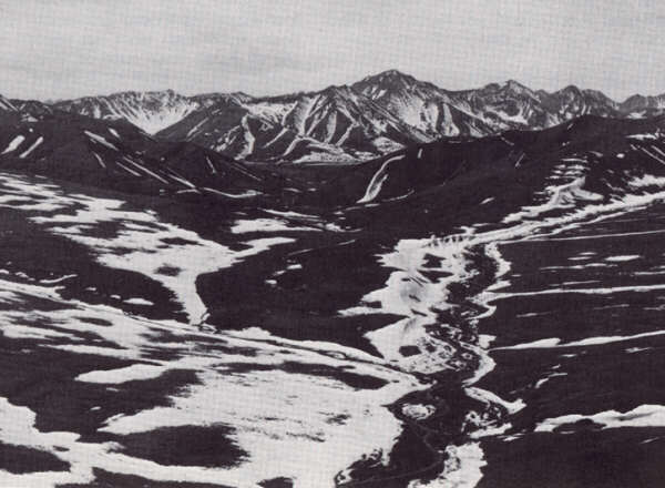
The subregion includes all or part of the following physiographic features:
De Long Mountains, Arctic Foothills, Noatak Lowlands, Baird Mountains, Central
Brooks Range, Ambler-Chandalar Ridge and Lowlands, Pah River, Selawik Hills,
Buckland River Lowland, the northeast part of the Seward Peninsula, and Nulato
Hills (Figure 57). The headwaters of the subregion's major streams, the Kivalina,
Wulik, Noatak, Kobuk, and Ambler Rivers, rise in the De Long and Baird Mountains.
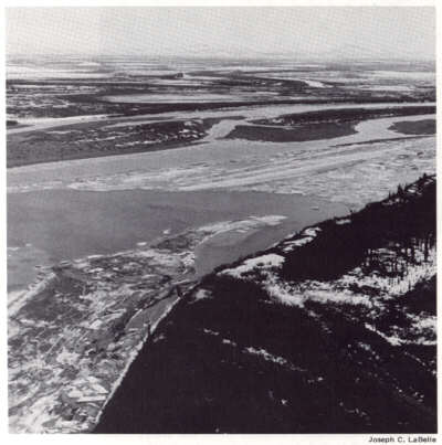
As the Kobuk skirts the southern edge of the Baird Mountains, it passes sluggishly
through a broad river floodplain and lake-dotted lowland that merges with the
lowlands of the Selawik River and lake system. Together they pass at their seaward
margins into deltas along Kotzebue Sound.
The largest freshwater lakes in the subregion are Imuruk (28 square miles),
Walker (14 square miles), and Shelby (eight square miles). Selawik Lake is much
larger, but is affected by tidal action. Lakes in the Kotzebue Sound Subregion
fall into four groups: those resulting from the regional deformation where downwarped
areas along the seacoast formed large collecting basins; glacial lakes scattered
throughout the mountains and foothills; tundra lakes of all shapes and sizes
that occupy the bench and flat valley lands; and lakes formed by volcanic action
on the central Seward Peninsula.
Permafrost is extensive in the north and only slightly less in more southern
areas. Exceptions are near major rivers. There are no glaciers, but several
snowfields last from year to year.
The climate is mostly maritime with annual averages of 93 frost-free days and
less than 20 inches of precipitation, including 50 to 60 inches of snow. Temperature
and temperature variations, especially along the coast, are low and winds are
often strong. The Noatak and Kobuk River valleys are characterized by greater
seasonal variation and are more continental in nature.
The subregion is sparsely populated and most communities hug the coast to take
advantage of the abundant sea life. Other than Kotzebue, important communities
and their populations are Noorvik (462), Selawik (429), Point Hope (386), and
Kiana (278).
Surface transportation consists mostly of a network of winter trails, some
prehistoric, that link some communities and river and coastal travel in summer.
Roads are practically nonexistent.
Norton Sound Subregion
 The Norton
Sound Subregion is essentially the southwestern three-fourths of the Seward
Peninsula and the coastal drainages as far south as St. Michael. The area is
26,000 square miles (67,000 km2), bounded on the east by the Nulato
Hills, on the south and southwest by Norton Sound (a part of the Bering Sea),
on the west by the Bering Strait which joins the Bering and Chukchi Seas, and
on the northwest by the Chukchi Sea. The Seward Peninsula encompasses practically
all types of land features including mountains, highlands, plateaus, coastal
plains, and interior basins and valleys.
The Norton
Sound Subregion is essentially the southwestern three-fourths of the Seward
Peninsula and the coastal drainages as far south as St. Michael. The area is
26,000 square miles (67,000 km2), bounded on the east by the Nulato
Hills, on the south and southwest by Norton Sound (a part of the Bering Sea),
on the west by the Bering Strait which joins the Bering and Chukchi Seas, and
on the northwest by the Chukchi Sea. The Seward Peninsula encompasses practically
all types of land features including mountains, highlands, plateaus, coastal
plains, and interior basins and valleys.
The subregion has an extensive coastline including King, St. Lawrence, and
Little Diomede Islands. The coast extends west from Kotzebue Sound and around
the Seward Peninsula into Norton Sound. It then courses eastward, stopping at
the village of St. Michael and Stuart Island at about the north-south center
of Norton Sound. The coastline is characterized by low barrier spits and islands
and lagoons along the Chukchi and Bering Sea coasts. Physiographic provinces
include Seward Peninsula, Bering Platform, Kuskokwim Coastal Lowland, and the
Nulato Hills (Figure 57).
Principal rivers which drain the subregion are the Unalakleet (2,080 square
miles), Koyuk (1,968 square miles), Kuzitrin (2,600 square miles), Niukluk (2,189
square miles), Shaktoolik, Ungalik, Amiapuk, and Serpentine. The continental
divide extends in an east-west direction, dividing the Seward Peninsula into
drainages to the Chukchi Sea from those flowing in the Bering Sea.
Lakes in the subregion conform to the four types described for Kotzebue Sound.
Shishmaref Inlet (15 square miles and tidal), Imuruk Basin (15 square miles
and tidal), Lopp Lagoon (18 square miles and tidal), and Walker Lake (14 square
miles) are the largest lakes.
Permafrost is continuous throughout the subregion, but it is less thick than
in more northern areas. The permafrost appears to be thawed only near deep lakes
or major streams. There are no glaciers in the subregion.
 The
climate is mostly transitional except for the extreme eastern corner, which
is continental, and some coastal areas which are maritime. Normal average summer
temperatures range from 30 to 50 degrees F and normal average winter temperatures
from five to 10 degrees F. The subregion averages 77 frost-free days a year.
Precipitation ranges from 15 to 20 inches a year. On the Seward Peninsula, St.
Lawrence Island, and in other areas contiguous to Norton Sound, the climate
is moderated by the Bering Sea and is essentially maritime.
The
climate is mostly transitional except for the extreme eastern corner, which
is continental, and some coastal areas which are maritime. Normal average summer
temperatures range from 30 to 50 degrees F and normal average winter temperatures
from five to 10 degrees F. The subregion averages 77 frost-free days a year.
Precipitation ranges from 15 to 20 inches a year. On the Seward Peninsula, St.
Lawrence Island, and in other areas contiguous to Norton Sound, the climate
is moderated by the Bering Sea and is essentially maritime.
Population is low and scattered throughout the subregion. In addition to Nome,
major settlements and their populations are Unalakleet (434), Gambell (372),
and Savoonga (364) on St. Lawrence Island.
Only a few intrasubregional roads exist, and there is no connection to the
rest of the state. Winter trails, however, are extensive, including a major
portion of the historic Iditarod Trail linking the Unalakleet River, Shaktoolik,
Koyuk, and Elim to Nome and another 125-mile trail connecting Wales and Singeak.
Summer surface transportation depends heavily on rivers and the sea.
[Alaska Regional Profiles, Northwest Region, pp. 3-4]
[Alaskool Home]