The settlement patterns of the Tlingit and Haida were strongly influenced by
the great variety and number of natural resources of both land and sea. The
Tlingit and Haida established two basic types of settlement: permanent winter
villages and temporary summer villages close to their fishing and hunting grounds.
Permanent villages were usually located on the narrow sand beaches of bays,
inlets, and lower river courses with the forest behind and a good view of the
water approaches to the village. Both Aurel Krause, the German ethnologist,
and Ivan Petroff, a Census Bureau official, commented on aboriginal summer nomadism:
Like all the inhabitants of the Northwest Coast, the Tlingit are a sedentary
people. In the summer, however, they lead a nomadic life, for they scatter
according to clan and family lines to their hunting and fishing territories,
or undertake extensive voyages, which sometimes last for months in order
to trade with whites or neighboring Indians (Krause 1880).
The Thlinket, like most of the tribes of the northwest coast of North America,
may be called marine nomads, as they occupy fixed dwelling places only during
the winter, roving about during the summer in search of food for the winter
(Petroff 1880).
Villages varied in size from a few houses to settlements of 50 or more houses
spaced about 50 to 100 feet apart :in ordered rows. Lisianski, the Russian explorer,
commented on the houses in the winter villages:
The barabaras of the Sitkan people are of a square form, and spacious.
The sides are of planks; and the roof resembles that of a Russian house,
except that it has an opening all along the top, of the breadth of about
two feet, to let out the smoke. They have no windows; and the doors are
very low to enter. In the middle of the building is a large square hole,
in which fire is made. In the houses of the wealthy, this fire-place is
fenced round with boards; and the space between the fire-place and the walls
partitioned by curtains for the different families of relations, who live
together in the same house. Broad shelves are likewise fixed to the sides
of the room for domestic purposes.
Each Indian group of Southeast had characteristics similar to individual nations.
They had a common language, name, and set of customs. Each "nation" was divided
into two groups called phratries, each with its own totemic system. These phratries
were essentially ceremonial and consisted of clans whose members could not intermarry.
Among the Tlingit there were two principal phratries: the Raven, most common
in the south, and the Wolf (sometimes referred to as the Eagle) in the north.
Similarly among the Haida there was an Eagle and a Raven phratry.
A number of clans were in each phratry. Authorities differ as to the precise
number of active clans among the Tlingit, but there seems to have been about
15 at the time of Russian contact in 1741, each established within more or less
clearly defined geographic boundaries (Figure 141). The Haida clans were far
less numerous.
Local clan division was the primary owning, organizational, and management
group. Clan membership established the relationship of an individual to clan
property. Property rights were only protected to the extent that the clan stood
behind them. All clan members were bound by common consent to defend clan property
against outsiders, share the use of their property among themselves, and enforce
the rules established by tradition and economic necessity. Traditionally, clan
property consisted of salmon streams, berry patches, sealing rocks, house sites
in the villages, and in some instances trade trails into the interior, hunting
grounds which usually consisted of the watersheds of streams or valleys, and
well-defined tracts of open sea such as halibut banks located by lines of sight
on prominent landmarks. As de Laguna stated in 1973:
If our picture of the world is that of the farmer, property owner and landlubber,
the Tlingit's is that of the traveler, especially the mariner, who is concerned
with places and the routes between them. The world for the Tlingit is probably
visualized more as it is in our sailing and harbor charts than as it is
in our political areal maps, for such charts reduce the land to landfalls,
to reefs, shoals, and anchorages to be avoided or sought and they sacrifice
or distort lineal and area measurements to emphasize angles or direction.
Sib territorial rights do not refer then to areas but to specific spots:
fishing streams, coves, berry patches, or house sites, etc., and the terrain
or water between these places are simply the relatively undifferentiated
landscape through which one travels in going from one to the other.
Each clan was based on maternal descent and consisted of a group of brothers
and their male cousins who, together with their families, lived in one or more
houses depending on their number. The minimal political and social unit of the
Haida, Tlingit, and the Tsimshian was the local house group. Each village had
its highest ranking house, the chief of which, usually the eldest brother of
the group, was recognized as the highest ranking local clan chief. Marriage
within the clan or phratry was forbidden, so villages were usually comprised
of two or more local clans from opposite phratries.
The house groups were generally, but not always, cohesive units held together
by the fundamental principles of common social identity, ownership, enterprise,
inheritance, and leadership (Lisianski 1804). The house itself, slaves, large
canoes, important arms, trade goods, and many of the utensils as well as noneconomic
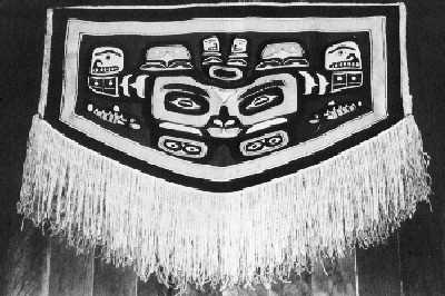
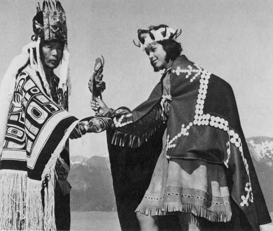
property such as totem poles, house crests, dances, and ceremonial objects were
the common property of the house group. There was, however, a great deal of
individual property in the form of hides and pelts which the men of the house
group accumulated for themselves by their own individual effort. The important
economic activities of salmon fishing, oil making, berry picking, hunting, and
trading were performed jointly.
The house chief in both societies was pre-eminently a ceremonial leader, a
repository of myth and social usage, and an educator of the young men of the
house group. He was primarily responsible for the trading activities of the
group and the symbol of house group solidarity. As such, he represented the
group in clan councils. In feuds or minor disputes he held the group in a solid
front against all external infringements. The house chief decided when the seasonal
fishing should begin and directed the work of slaves and of poor men without
relatives.
Very small groups which settled in unoccupied places and built one or two houses
were the basis of Haida and Tlingit villages. Among the Haida the first settlers
established rights to ownership of economically strategic resources within the
reach of the village, developed political leadership beyond that of the house
chiefs, and recognized "village masters." The Tlingit did not develop similar
leadership, and their villages appeared to consist of autonomous house groups
presided over by independent house chiefs or "yitsati."
Traditionally, rights to territory that were properly validated in potlatches
were inalienable. However, there are reports that such property sometimes changed
hands. The Taku Tlingit are reported to have rented their fishing rights to
other clans. Failure to use an area was regarded as abandonment and justified
occupation by new claimants.
It appears that territory was sometimes acquired by conquest, and it is quite
likely that the southeast Indians with their highly developed notions of property
and indemnity were prepared to defend their property rights with their lives
and to exact just retribution for trespass. Oberg (1973) pointed out that offenses
against the life, property, and honor of a Tlingit were settled by a payment
of goods and that such indemnities constituted an important form of wealth.
The economic year of the southeast Indians was based on the seasonality of
resources. As spring approached, canoes were hauled from winter storage, their
bottoms cleaned of slivers with a pine torch, and fishing and hunting gear prepared.
Figure 143
The Tlingit Economic Year
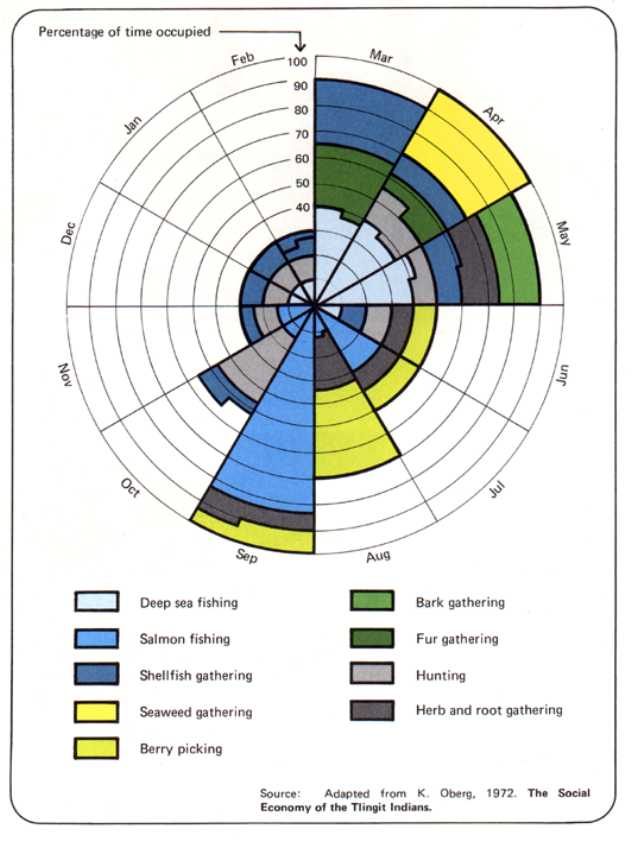
The eulachon (candlefish) runs began in February or March. Eulachon were highly
prized for their valuable oil which was stored and used year-round. Also, in
March halibut and cod were caught off the coastal islands, while on the mainland
trout fishing predominated. Halibut, though secondary to salmon, was a major
protein source in Southeast and was eaten in immense quantities. Traditional
halibut fishing gear consisted of wooden hooks tipped by a bone barb attached
to rawhide cedar bark or kelp lines. The fishing rig was particularly ingenious
for it allowed the Indian fisherman to protect his bait from "trash fish" such
as sculpin and rock fish for only the flat-headed halibut or flounder could
get at the bait. So effective was this gear that even after the advent of the
European, it continued to be used, modified only by the substitution of iron
tips for bone.
Trout were taken with gill nets of rawhide or cedar bark twine that were drifted
downstream by two men in a canoe, one paddling and the other retrieving the
net. Great quantities of trout, particularly Dolly Varden, rainbows, and cut-throat,
were taken this way, and in early spring catches were generally eaten fresh.
Throughout March a variety of clams, crabs, mussels, cockles, and snails and
several types of seaweed were gathered. Throughout most of April, deep-sea fish
continued to be taken, and sea mammals were hunted to supplement the fish diet.
Sea otters were generally available in the inner bays of the Tlingit territory
and were highly prized for their pelts, a valuable trade item. Seals were harpooned
by hunters in light canoes in the shallow coastal waters, but whaling was never
important among southeast Indians except the Yakutat Tlingit.
Cranes, ducks, geese, grouse, gulls, kittiwakes, ptarmigan, and swans and their
eggs were taken. However, while birds and eggs were relished, they were never
of major importance in the southeast Alaskan Indian diet. A variety of grasses,
roots, and weeds useful as food, medicine, and fiber was collected and stored
for later use. The tender stems of the salmonberry, wild rhubarb, wild clover,
and peas of the purple vetch were collected and eaten. The bark of the hemlock
was peeled off and the soft white cambium layer was scraped off, cooked, pressed
into cakes, and stored in boxes for winter use.
Herring swarmed into the mouths of numerous coastal rivers in May, attracting
in their wake porpoises, whales, and seals as well as many kinds of fish. Herring
was harvested, principally for roe and oil, with a herring rake, dip baskets
and nets, dragging nets, or simply by a jigging line set with several hooks.
De Laguna reported that in the old days: "Schools of herring used to crowd so
tightly into the bays that a strong arm was needed to drive the fish rake through
the mass of their bodies."
Trade was an important part of the economic and social life of aboriginal southeast
Indian groups, and most was conducted in late spring. The regional distribution
of resources resulted in regional specialization of production and in regional
interdependence.
... we can see it even today in the household possessions of the Tlingit,
which are the products of many different places. The caribou skin which
the Chilkat use for their clothing, the sinew with which they sew, the lichen
with which they dye their dancing blankets are all secured through trade
with the Athapascan-speaking Indians of the interior. The dentalium, the
sharks' teeth and pieces of mother of pearl. . . which they wear as jewelry
in their ears or hang as pendants, on a thong around the neck come from
the south, principally from the Queen Charlotte Islands. (Krause 1880)
Trade was usually conducted in well-established patterns between trade partners
who generally were either actually or quasi-related. Each group established
monopoly over specific trade routes and spheres of influence which they jealously
guarded. The Wrangell clans are reported to have held trading rights with the
Athapascans at the headwaters of the Stikine River, while the Taku people on
the Taku River and the Chilkat on the Chilkat River exercised similar monopolies.
This monopoly of specific trading areas and routes was so strong that it became
one of the major areas of friction between American traders and Indian groups
during the late eighteenth and throughout the nineteenth centuries. The Hudson's
Bay Company established a trading post about 1854 in the Yukon Valley, which
the Chilkats marched inland and destroyed.
The major river systems of the Yukon and the Mackenzie were navigable and provided
a conduit to the Interior. The Chilkat, Stikine, and Taku actively traded with
interior Natives along these "grease trails," so-called because the primary
trade article was candlefish oil. From the Interior the coastal people obtained
prepared moose hides, dried meats, jade tools, copper, highly decorated moccasins,
birch bows wound with porcupine gut, and prepared caribou hides. The hides were
highly valued for making shirts and trousers. Thongs and sinews of various kinds
were traded by the interior people for cedar bark, baskets, fish oil, iron,
shell ornaments, and plates of copper.
After the fall fishing season,
the people moved back to their permanent winter villages and resumed the traditional
round of basket and blanket making, house building, and other ceremonial and social
activities such as the potlatch. This complex part of southeastern aboriginal
culture combined concepts of acquisitiveness, property, and competition.
In the late seventeenth and early eighteenth centuries a world-wide curiosity
speculated on the whereabouts of the western opening of the Northwest Passage
and whether Asia and North America were joined somewhere in the Arctic. The
question of a continental connection inspired a series of Russian voyages between
1725 and 1741 led principally by a Dane, Vitus Bering.
Bering made his last voyage in 1741 with Alexei Chirikov, and it was to have
important consequences for southeast Alaska. They sailed from Petropavlovsk-on-Kamchatka
and made the first recorded European landfalls on the southeast Alaska coast
at Cape St. Elias on July 17, 1741. Georg Wilhelm Steller, a German naturalist,
accompanied Bering on the St. Peter and explored Native houses on southern
Kayak Island and recorded observations of the flora and fauna in the region.
Fleet Master Sofron Khitrov made similar explorations on Wingham Island, but
none of Bering's crew reported sighting Alaska Natives. Chirikov commanded the
St. Paul, the second ship of the expedition, and landed somewhere in
the vicinity of Cape Edgecumbe and coasted north to Chichagof Island where he
encountered hostile Tlingits.
Chirikov returned safely to Russia, but Bering was shipwrecked and died of
scurvy on one of the Commander Islands. The survivors of Bering's crew killed
and skinned hundreds of sea otters and returned to Siberia with the valuable
pelts. The expedition produced a tentative answer to the question of continental
connection, but clarification had to wait until Captain Cook charted Bering
Strait in 1778.
The Russians, meanwhile, were far more eager to exploit the fur resources of
the Aleutians. The year after Bering's 1741 expedition returned, Emelian Basov
sailed to the island where Bering died and verified the presence of thousands
of sea otters in the eastern ocean. For the next 56 years, 1743-1799, the search
for richer fur-hunting grounds was the major impetus to the Russians' movement
across the Aleutians and along the Gulf of Alaska to the Alexander Archipelago.
Most of these ventures originated from the Siberian ports of Okhotsk or Petropavlosk
and were financed by Siberian merchants like Gregor Shelekhov, whose company
would establish the first permanent settlement at Kodiak and later evolve into
the government-sponsored monopoly called the Russian-American Company. The Russian-American
Company became, in effect, the legitimate representative of the Russian authority
in America. Alexander Baranov was appointed as the first governor of the company
and its territories.
Between 1774 and 1791 the Spanish, fearful of losing their Pacific domain,
sent explorers up the coast where they briefly held Nootka Sound. Between 1785
and 1800 many English, French, Russian, and American ships explored the coastal
areas of Southeast. Some of these explorers, like Cook in 1776 and Vancouver
in 1792-94, headed expeditions that were primarily exploratory, but most were
primarily interested in expanding their nation's fur-trading operations. In
the 1790s as many as 20 to 30 ships a year anchored at Nootka Sound, Parry Passage
at the north end of Graham Island, and Cordova Bay across from Dixon's Entrance.
As competition in the sea otter trade became keener, exploration of the more
northerly areas increased, and the Tlingit and Haida were drawn gradually into
the commercial fur trade. Many crews traded directly with the aboriginal inhabitants
in their summer camps during the annual harvest of salmon and other fish and
seafood resources. Most of these expeditions included clerics, naturalists,
geographers, cartographers, and artists, and much of our present information
concerning the life of Southeast's aboriginal inhabitants is owed to these men.
The Russians continued to move west, searching primarily for new sea otter
hunting grounds, although the dense stands of hemlock and spruce in southeast
Alaska were also attractive to them. The first organized movement into Southeast
was undertaken in 1788 by Sturman Ismailof and the Cossack Bocharof who, with
a large hunting force, penetrated as far as Yakutat and Lituya Bays. In 1795
Baranov led another large band of hunters into the Lynn Canal area, home of
the aggressive Chilkat Tlingits. In 1796 Baranov sent a group of about 30 Russian
families from Kodiak to Yakutat Bay to establish an agricultural colony to counter
the growing influence of British and Yankee traders in the area. The settlement
did not prosper. They quarreled among themselves and had poor relations with
the Natives. During the first winter 30 of the settlers died of scurvy, and
the community's importance dwindled.
Baranov turned his attention to securing a Russian foothold on Sitka. In 1799
he led a large group of Russian and Native hunters to Sitka Sound, where after
apparently friendly negotiations with the Sitka Tlingit, a small fort named
the Redoubt Archangel Michael was established. When Baranov returned to Kodiak,
instructions from the company to move their headquarters to the new fort on
Baranof Island awaited him. The promise of new sea otter hunting grounds, unlimited
timber, and good harbor inspired Baranov to comply rather enthusiastically with
the directive.
The Russians who had remained at the new settlement were having second thoughts.
They had misjudged the hostility of the Sitka Tlingits, whom they had outraged
by seizing hostages. In June 1802 the Tlingit attacked the Redoubt Archangel
Michael and destroyed it, killing all the inhabitants but a few who were rescued
and returned to Kodiak by an English trader. De Laguna reports that most of
the Tlingit tribes in the area probably took part in the attack, and they might
have been assisted by English and American seamen who had jumped ship or been
marooned at Sitka in 1799. It has further been claimed that British traders
may have incited the Indians in hopes of eliminating Russian competition.
Baranov was not deterred. In 1804 he sailed into Sitka Sound with a force of
120 Russians and about 800 Aleuts. The Sitka Tlingit had abandoned their town
of Sitca and built a new fortified town at the mouth of the Indian River. Baranov's
force occupied Sitca in September 1804, renaming it New Archangel. With the
aid of several Russian naval vessels, commanded by Captain Urey Lisianski, he
mounted an eight-day siege of the Indian River fort. New Archangel, present-day
Sitka, became the new headquarters for the Russian-American Company.
The Russian hold on southeast Alaska was rather tenuous, and their settlements
had to be heavily guarded. The Tlingit's dominance, reinforced by the willingness
of most non-Russian traders to let them retain their traditional autonomy, was
based in part on their ability with firearms. Spears and arrows, according to
Lisianski were almost a thing of the past by 1805.
Russian control in southeast Alaska was being challenged in the early 1820s.
In 1825, a Russian-British convention defined their territories and established
the Russian-American southern boundary at latitude 54.40. This boundary was
violated by the Hudson's Bay Company, but a direct confrontation over British
rights to establish a trading post on the Stikine River near present-day Wrangell
resulted in a settlement between the two governments whereby the Hudson's Bay
Company gained control over a large area of southeastern Alaska until the American
purchase.
A terrible smallpox epidemic spread from California to Alaska, appearing first
at Sitka in 1836. In the village near the Russian fort 400 Natives died within
three months, representing almost half of the population. Angoon suffered severely,
as did villages between Yakutat and Dry Bay. Veniaminov, the Russian cleric,
estimated that by 1840 there were less than 6,000 Kolosh (Russian for
Natives in southeast Alaska) whereas in 1833 there had been as many as 10,000.
During the decade of the 1840s, southeast Alaska served as a center of important
industrial and fur-trading activities. Sitka flourished briefly as a shipbuilding
center during the 1840s to 1850s. The industry did not last long, however, for
more seaworthy ships were built for less in British and American shipyards.
Nonetheless, shipbuilding stimulated Russian interest in supplying coal for
the new steamships.
With the fur trade in serious decline, the Russians felt that developing the
mineral resources of the region might enable them to hold on to their American
possession. Accordingly, in 1849 Peter Doroshin, a graduate of the Imperial
Mining School at St. Petersburg, was commissioned to study the mineral potential
of the colony. He located coal deposits at Port Graham on the Cook Inlet but
was prevented from good prospecting in Southeast because of Hudson's Bay Company
control of the then-unknown gold-bearing belt.
Through the 1850s southeastern Alaska, and Sitka particularly, enjoyed something
of a gracious age. Commerce resulting from the Pacific tea trade kept the economy
going. Whaling was attempted with only moderate success on the Fairweather grounds,
but other industries developed in the little town of 1,278 people. The influx
of gold seekers into California provided the Sitka Company with a market for
ice, and for several years tons of ice were shipped from Southeast to San Francisco
at about 25 dollars a ton. That trade was soon lost to Southeast when the company
moved its ice operations to Kodiak. The Russian search for minerals never resulted
in substantial enterprise.
Baranov Castle, the official home of the Russian governors, was built in the
decade starting in 1826 and provided the setting for a frontier facsimile of
St. Petersburg court life. A succession of gracious Russian women, among them
Baroness von Wrangel, Lady Etolin, and Princess Maksoutoff, helped to make frontier
life less elemental. The company opened a Colonial Academy at Sitka where young
Russians and some creoles were trained as surveyors, navigators, engravers,
and accountants. Much of the work for Tebenkov's Atlas of Alaska was
done by young men trained at the Sitka Academy. Lady Etolin established a school
for young ladies where they were taught the essentials of good breeding. A theological
school, later upgraded to a seminary, was established in Sitka in 1841, but
it only operated for a short time. Several notable clerics worked in Southeast,
among them the indomitable Father Veniaminov, who came to Sitka in 1834 and
in subsequent years wrote a treatise on the Tlingits.
Despite this flicker of gentility in Southeast, it became evident by the late
1850s that Russia's hold on its American possessions was definitely waning.
Blocked from exploiting new lands to the south and east, while their own fur
resources continued to decline, the Russians faced serious economic difficulties
compounded by the geopolitical ambitions of the British. Perhaps the statement
of the Russian Minister of State Property in 1862 best summarizes the situation:
The main pursuit of the colonies—the hunting of sea otter—has been gradually
on the decline. Generally speaking, the fur business has begun to yield
first place to Canada and Great Britain. Whaling in the colonies has passed
into the hand of the Americans. Fishing has been done on a scale which barely
meets the needs of the colonies themselves . . . Nothing has been done with
respect to farming and cattle breeding. The mineral resources of the region
have hardly been tapped; the commercial relations that the Company has maintained
have been seriously impaired and are falling into decay, its merchant marine
has been allowed to be reduced to negligible proportions, and it is compelled
to charter foreign boats to meet its own requirements.
The unilateral Russian attempt at penetration and domination of the Tlingit
was, for the most part, ineffective. The Tlingits' culturally unified view of
themselves inhibited any massive onslaught on traditional Native ways and customs.
In 1867 Russia sold its American possessions to the United States for $7.2 million.
Despite Tlingit claims that all the Russians were entitled to sell were the
lands on which their installations stood or lands they actually controlled,
all land and other property passed to the United States government.
On October 18, 1867, General L.H. Rousseau, escorted by a small contingent
of U.S. soldiers from the ninth infantry, officiated at the transfer of the
Russian possessions to the United States. The Tlingit were introduced to a new
political order, in which the only law was that of armed soldiers who were often
busily breaking the law themselves, and a new economic and social order in which
money was the primary medium of exchange. The ancient trading system with all
its rich complexities was quickly outmoded. Alaska became, in effect, a military
outpost of the federal government.
For some months after the change in ownership, Sitka enjoyed a boom. Opportunists
of all kinds, from preachers to prostitutes, headed north with their dreams.
Between 1867 and 1869 some 70 ships crowded into Sitka harbor from San Francisco,
British Columbia, Hawaii, Asia, and Russia and returned to West Coast ports
bearing sheathing and bar metal, lead, bales of furs, and other sundries from
the dismantled Russian installations.
The first years of American control were extremely disorganized with neither
effective civil nor military government. Between 1867 and 1884 Alaska was ruled
by officials of the War, Treasury, and Navy Departments. Only two substantive
laws were enacted with regard to Alaska; one created a customs district in Alaska
and the other turned over the Pribilof sealing grounds as a monopoly to a private
San Francisco company. For 17 years it was not legally possible in Alaska to
get married, obtain land title other than to small tracts deeded to the Russians
at the time of the purchase or by special Act of Congress, bequeath property,
or collect debts. Some local efforts were made to bring a semblance of control
to southeast affairs. Within 30 days of the transfer, a town meeting in Sitka
framed a charter, elected a mayor and council, and drew up city ordinances.
Despite official neglect, various scientific expeditions were sent to investigate
the area's resources, survey coastlines, and harbors, and generally to collect
data which might be useful in developing the new possession. One of the most
significant of these expeditions was that of Ensign A.P. Niblack who gathered
information in the summers of 1885-1887. He made photographic studies of the
Haida but did not reach northern Tlingit settlements. Other quasi-governmental
and private officials made studies of the Tlingit and Haida. Among the most
useful are those of W.H. Dall, Ivan Petroff, Lt. W.R. Abercrombie of the Second
U.S. Infantry, and the Harriman Expedition of 1899.
The year 1878 marks a turning point in the American period of southeast Alaska,
for in that year the first commercial cannery was established at Klawock on
Prince of Wales Island and a second at Sitka. The first full-fledged gold mining
camp was established at Windham Bay. The gold discovered in the Cassiar District
of British Columbia in the 1870s led to prospecting in the Stikine River valley,
and Wrangell became a boom town. Prospectors spread from the Stikine and Cassiar
Districts into the Alexander Archipelago and the neighboring mainland.
George Pilz, a German mining engineer who had come to Sitka in 1877, together
with N.A. Fuller, a merchant, grubstaked prospectors who worked the coastal
areas and offshore islands of Southeast in response to Auk Tlingit reports of
gold found in the Gastineau Channel. Pilz and Fuller contracted with Richard
Harris and Joseph Juneau, two miners who had worked in the Stikine and Cassiar
fields, to prospect the coastal areas of northern Southeast.
After several months of poor luck, Juneau and Harris struck gold-bearing quartz
along Gastineau Channel near the present state capital of Juneau. News of this
find led directly to the founding of the city of Juneau as miners flocked to
the new bonanza. Commander Henry Glass went to the new gold site and established
naval barracks, the Northwest Trading Company sent Edward DeGroff to the area
with supplies to open a store, a new customs house was established, and a post
office called Harrisburg was created.
In 1882 French Canadian miner Pierre Erussard found placer gold on Douglas
Island opposite the new town of Harrisburg. This new find gave rise to the twin
city of Douglas, officially founded in 1887. Shortly after Erussard's discovery
a California mining magnate, John Treadwell, bought out Erussard. The Treadwell
mines produced over a half-million dollars in gold in a very short time. Meanwhile,
a controversy developed over the name of the mainland city. Another American
city was also called Harrisburg, and eventually the name of the Alaskan city
was changed to Juneau.
The founding of the twin cities of Juneau and Douglas gave rise to several
short-lived mining center satellites: Perseverance, Treadwell, and Thane. Ketchikan
began with the establishment of a salmon cannery in 1886 and saltery in 1888.
Fishing continued to be the mainstay of Ketchikan until it was eclipsed by the
timber industry in 1955. Skagway was the product of the Klondike gold rush of
1897, and during its early years was principally a transportation center to
the Yukon gold fields. The town of Petersburg also appeared in 1897 as a fishing
and canning center. In 1900 Juneau replaced Sitka as the territorial capital.
Craig was founded in 1907 as a salmon canning and cold storage site and became
a permanent center with a customs house and small logging and other fishing
industries. In 1908 Fort Seward, later named Chilkoot Barracks, was established
in the vicinity of Haines and was maintained as an army post before being sold
as surplus after World War II. It is now known as Port Chilkoot.
For the most part, the Natives of Southeast retained their tribal subdivisions
and maintained their integrity. Some Tlingits gradually gathered around Sitka
and Wrangell, while Indians from the Auk territory were attracted to Juneau.
Only six of the original precontact Tlingit settlements remain today: Yakutat,
Klukwan, Hoonah, Angoon, Kake, and Klawock. The village of Saxman near Ketchikan,
founded by the remnants of the Cape Fox people, is essentially an aboriginal
village, but was established under missionary influence. The only Haida settlement
remaining today is Hydaburg. Metlakatla was established under missionary influence
in 1887 and is the only active Tsimshian community.
News of the scenic grandeur of Southeast was circulated in the Pacific Coast
press, and tourist excursions to the area were initiated by the Pacific Coast
Steamship Company in 1884. By 1889 five thousand tourists were visiting Southeast
annually. These visitors avidly bought Native handicrafts, often paying as much
as $50 to $100 for furs and Native curios. The missionaries encouraged this
trade since these articles were usually connected with Native religious practice.
Reportedly, by 1890 most of the original Tlingit artifacts were sold off, and
the Indians had started a handicraft industry.
It is important to keep in mind that the history of Southeast is, in many ways,
coterminous with the history of Alaska. Southeast was home to one of Alaska's
most remarkable aboriginal complexes, the site of much of the Russian activity
in the state, and the region where American control was established and then
expanded and consolidated over the territory's vast resources. The people and
events that shaped Alaska's future also profoundly affected Southeast, and the
dynamic drive for greater civil, political, and economic freedoms in Alaska
reflect how closely the history of the region intertwines with that of the state.
Pressure for more effective government continued to increase. The powerful
Presbyterian missions and their energetic leader, Sheldon Jackson, accelerated
this demand. A forceful public speaker, Jackson played an important role in
awakening Americans to Alaska's needs. His major interest was education of Alaska's
Natives, but in his fight for Native rights, he allied his cause with the struggle
for better government. His talents served the territory well for many years.
Disputes over landholdings and mining rights and conflicts between civilians
and army officers over mining claims led to the declaration of martial law in
the area in 1881 and a meeting in Juneau to which miners from all over Southeast
were invited. The miners decided to send Colonel Mottram Ball as a delegate
to the 47th Congress with a petition asking for representation. He was refused
a seat and the petition was shelved, but Ball was treated respectfully and Congress
even appropriated some money for his expenses.
In 1884 Senator Benjamin Harrison of Indiana, fortified by the presence of
Jackson who had taken up residence in Washington, D.C., for the duration, sponsored
the first Organic Act, officially designated "An Act Providing a Civil Government
for Alaska." This bill, signed into law on May 17, 1884, provided for the regulation
and administration of justice in Alaska but did not include legislative privileges
to the territory. It provided for a presidentially appointed governor, created
a district court with judge, clerk, district attorney, marshal, and four commissioners
to handle minor legal matters. The court held two sessions a year, one in Sitka
and the other in Wrangell. The act specified that the laws of the State of Oregon
were, as far as applicable, to be in force in Alaska and proclaimed Alaska a
land district. Mining claims were to be registered with the four commissioners.
Until the Klondike gold rush in 1898 provided further incentive for additional
federal legislation, the Organic Act of 1884 remained the basic instrument of
government in the territory.
Along with the struggle to secure additional civil government in Alaska, the
boundary dispute between Canada and the United States also became a major issue.
The geographic basis of the resulting treaty was at best defective and over
several decades caused persistent tensions between Canada/Britain and the United
States. In 1903 the boundary dispute was resolved, largely in favor of the United
States, which caused long-lasting Canadian resentment.
The Klondike bonanza in the Yukon Territory captured the attention and imagination
of the world. The least arduous route to these gold fields lay up the Lynn Canal,
and it was crucial to the Canadians to have direct control of the harbors. Americans
strongly objected, and American customs were established at Skagway and Dyea,
while the Canadians established similar offices at the end of passes just a
few miles away. As a result of this stampede, Southeast enjoyed several years
of prosperity as gold seekers once again used the territory for a jumping-off
point.
From 1896 to 1900 several congressional committees worked on effective legislation
for the territory. The first substantive legislation were the Transportation
and Homestead Acts of 1898. Railways were freed from the jurisdiction of the
Interstate Commerce Commission, and homesteads were restricted to surveyed plots
of 80 acres. In 1899 the Criminal Code was enacted. The Carter Bill of 1900
in part provided for the establishment of a civil code for Alaska and three
judicial districts. Courts were established in Sitka and later moved to Juneau.
Civil government in Alaska was still considered inadequate in spite of the
fact that Congress was making progress. In 1899 discontent peaked in Southeast,
and a convention of delegates from Ketchikan, Douglas, Juneau, Sitka, and other
Alaskan centers met in Skagway. They favored a territorial government for Alaska,
and John G. Price was elected to lobby in Washington for territorial status.
His efforts were not very productive, principally because the Carter Bill—designed
to provide for more efficient administration of Alaska—was about to be passed.
Many congressmen felt that the demand for greater representation emanated primarily
from Southeasterners who wanted to dominate the rest of Alaska. It was not until
the 59th Congress in 1906 that Alaska secured the right to elect one delegate
to Congress who would merely serve as a source of information on Alaskan affairs.
In 1911 James Wickersham, a prominent jurist who was one of Alaska's most ardent
home rule advocates, and then Alaska's congressional delegate, introduced a
bill providing for an Alaskan territorial legislature. The bill encountered
some resistance, but was enacted into law in August of 1912. While the bill
did not provide full legislative authority, it was nonetheless a marked improvement
over the Organic Act of 1884. At about the same time southeast Indians organized
themselves in the Alaska Native Brotherhood and the Alaska Native Sisterhood.
These two groups provided a forum for discussion and expression among Southeast's
aboriginal inhabitants and remained a strong force in the Native movement.
The first legislature met in 1913 and worked diligently to secure full rights
for Alaskans. Among its first acts was to enfranchise women, seven years before
the federal government. It requested that Congress liberalize the land laws
to encourage and promote settlement in Alaska; it petitioned Congress to end
land reservations and withdrawals and to rescind some already made; it requested
better and more roads and lower freight rates.
The years after 1912 were problematic for Southeast. By 1918 fisheries production
peaked, and although there were booms in mining and forest production, it was
evident by the 1920s that economic domination of the territory by Southeast
would soon be threatened by developments to the north.
Several issues confronted the territory in succeeding years, not the least
of which was the resolution of aboriginal claims to lands in Southeast. No reservations
were set aside for the Indians in that region, except for the Tsimishian at
Metlakatla, and no treaties had been negotiated with them. The entire question
of rights to land and other resource areas was held in abeyance, although the
Natives had long maintained that their rights to the land had not been breached
by the Treaty of Cession. In 1935 the Tlingit and Haida people brought suit
in the U.S. Court of Claims for compensation for "lands and other tribal or
community rights." Claims were subsequently filed by a few Tlingit communities,
but the court denied them. The question again came up as a result of a section
of the Alaska Fisheries Regulations of 1942 that provided "no trap should be
established in any site in which any Alaska Natives have any rights of fishery
by virtue of any grant or of aboriginal occupancy."
The Department of Interior held hearings in Tlingit and Haida villages to determine
"fishing and other occupancy rights of these communities." Individuals testified
concerning their kinship groups and the areas they traditionally fished and
located their camps, smokehouses, and other sites. Native claims to resource
sites and lands were contested by canneries and other business interests, but
the Court of Claims eventually awarded the Tlingit and Haida residents more
than $7.5 million for lands withdrawn for the Tongass National Forest, the Annette
Island Reserve, and the Glacier Bay National Monument. Also, the court found
that "Indian Title" survived unextinguished to 2.6 additional acres of land
in the area. However, final resolution of Native title to lands in Southeast
was not definitively resolved until passage of the Alaska Native Claims Settlement
Act on December 18, 1971.
In the intervening years Alaska's uniqueness and value to the nation had been
proved. Her strategic geographic position became evident during World War II,
a massive military construction boom followed, and the quest for statehood became
a key issue.
As the final push of almost a half a century of dedicated, if somewhat
sporadic effort, the statehood movement of the 1950s pulled together diverse
and frequently conflicting interests and molded them into a common desire
for increased self-government and local control over the territory's natural
resources. A major product of this final effort—Alaska's constitutional
convention—built upon the consensus and enthusiasm generated by the statehood
cause, and in the process, rose to high levels of idealism and dedication.
The result was a very successful and a widely supported state constitution
(Fischer 1975).
Statehood was finally achieved in 1958. Southeast retained the capital in Juneau,
and that city grew enormously as government services and ancillary industries
established themselves there. Nonetheless, with the growth of cities on the
northern gulf and Cook Inlet, the focus of economic and political power gradually
began to shift out of the region.
Southeast is still important as the center of government services, although
in 1974 an initiative was passed to move the capital from Juneau to an as yet
undetermined site. The important wood processing and fishing industries still
center in Southeast, and these in turn have encouraged the growth of important
distributive industries. Southeast is still one of the most important economic
and political sections of the state. The region's vast array of natural resources
provided the basis for the beginnings of organized modern industry in the territory,
and its Native and non-Native peoples have been foremost in the fight to effect
a just settlement of the patrimony of all inhabitants of the state.
Figure 147
Important Dates and People in Alaska's History