Introduction
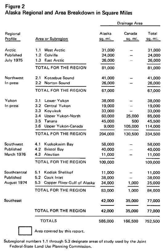
The Southeast Regional Profile is the fourth in a series of regional studies describing the natural and man-made environment of the state. The volumes of the profiles that have already been published (Figure 2) have proved the value of presenting basic data in a factual manner with simple text, charts, and maps. They have provided background knowledge for many studies ranging from the capital site selection process to the preparation of impact statements for offshore leasing. They have been used by consultants and teachers and as a model for data presentation by many state and federal agencies.
The format of the profiles was developed to provide a framework that would highlight the importance of understanding interrelationships among all components of the natural system before decisions about land use development and management are made. The consistent map scales and design throughout the series allow for comprehensive evaluation and comparison of facts on both a regional and statewide basis.
The data used in the preparation of the series were made available by the Joint Federal-State Land Use Planning Commission and Resource Planning Team established by the Alaska Native Claims Settlement Act on December 18, 1971. In 1972 through 1973 this team of 34 professionals in various fields of natural resources and planning gathered data on the natural and man-made environment of the state for the commission's use. We used the commission data to develop the format of the profiles, added knowledge in several disciplines, and expanded explanations when necessary. The extensive bibliography directs the reader to documents which have greater detail in specific resources, geographic area, or scientific topics.
Description of Planning Units
Alaska has a land area of 586,000 square miles or approximately 375 million acres. Because of the size of the state and the diversity of the land and its resources, the Joint Federal-State Land Use Planning Commission has divided the state into six major planning regions (Figures 1 and 2). The regions and subregions follow hydrologic boundaries; that is both the regions and subregions include the watersheds of streams within their boundary with no regard to the township and range-grid systems or political subdivisions.
The Southeast Region covers an area of approximately 42,000 square miles. The Alaska portion is part of a larger drainage system covering approximately 77,000 square miles. A portion of this system is in Canada (Figure 2). The Southeast Region contains several large units of governmentthe City and Borough of Juneau, the City and Borough of Sitka, and the Ketchikan Gateway Boroughand all the land that will be selected by Sealaska under the Alaska Native Claims Settlement Act.